
SYNOPSIS: A warm southwest flow will be in place across the state for today and Thursday. Moisture and energy within the southwest flow will be increasing on Thursday as a Pacific low pressure system starts to cross the Rocky Mountains. A weak cold front will also push across the state late Thursday. Scattered weak showers and a few thunderstorms are likely today for western, southern and central areas. Rainfall though from today's activity will be minimal and temperatures will be 10 to 15 degrees above normal.
Shower and thunderstorm activity will be more widespread on Thursday and the activity will also be better rain producers. A few strong to isolated severe thunderstorms cannot be ruled out Thursday afternoon or evening in the east and southeast. The main threat of severe weather though will be to the east, southeast of Wyoming. Snowfall today and Thursday will be limited and confined to elevations above about 9,000 feet. However, the snow level will be dropping on Thursday night into Friday.
A moist and cool Pacific low pressure system will then wind up over eastern Colorado and western Kansas on Friday. This weather system is not cold enough to produce snow below about 7,000 feet. However, moderate to heavy spring snow will be likely across the state's mountains starting on Friday. Friday night and Saturday look to be the best timeframe here now for accumulating mountain snowfall but some will linger into Sunday. Saturday night could also bring the snow level down to about 6,000 to 6,500 feet! Widespread light to moderate rain will be falling across much of Wyoming come Friday and Saturday. Precipitation amounts in excess of an inch will be likely in areas. Some precipitation will linger into Sunday. Please see the extended outlook below.
TODAY:
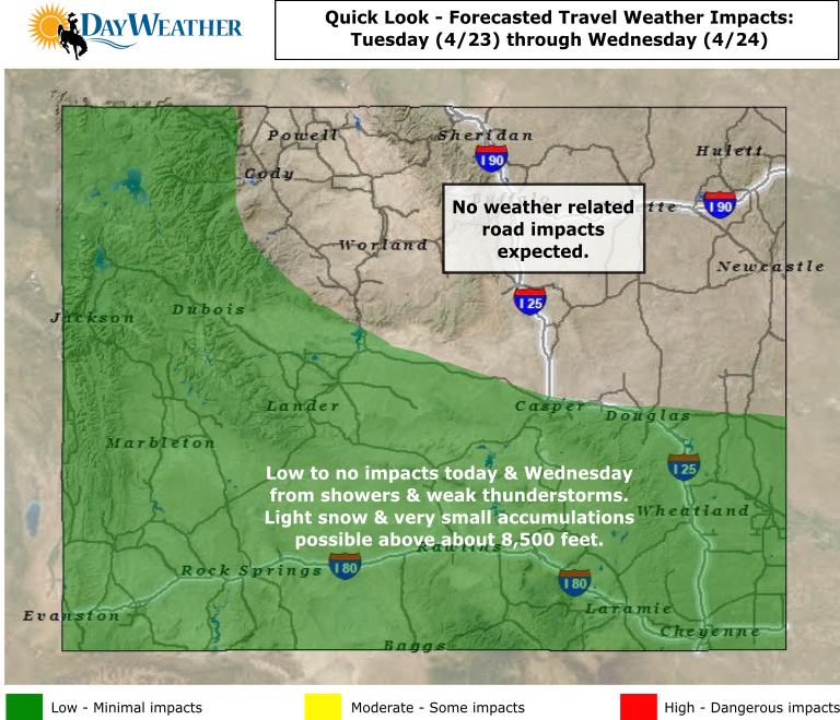
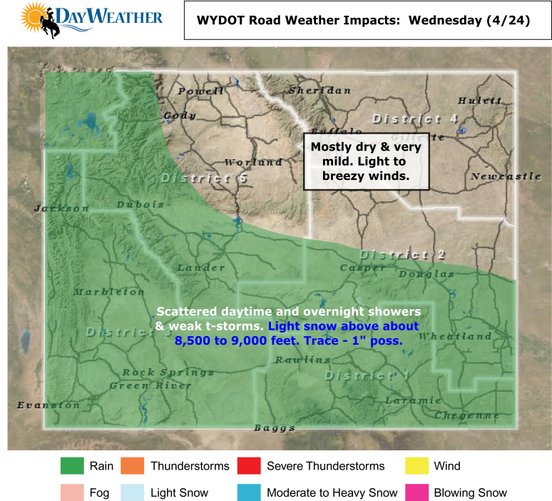
Rain/snow: Scattered rain showers and a few weak thunderstorms with higher elevation snow showers across western, central and southern areas. The snow level will drop to about 8,500 feet. Please see the graphic below.
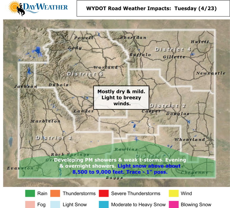
Winds: Light to breezy, below criteria winds statewide.
Temperatures: Highs upper 60s to lower 70s for the plains with upper 50s and 60s in the valleys with 40s and 50s in the mountains. Lows teens to 20s in the mountains with 20s to lower 30s in the valleys and 30s in the plains.
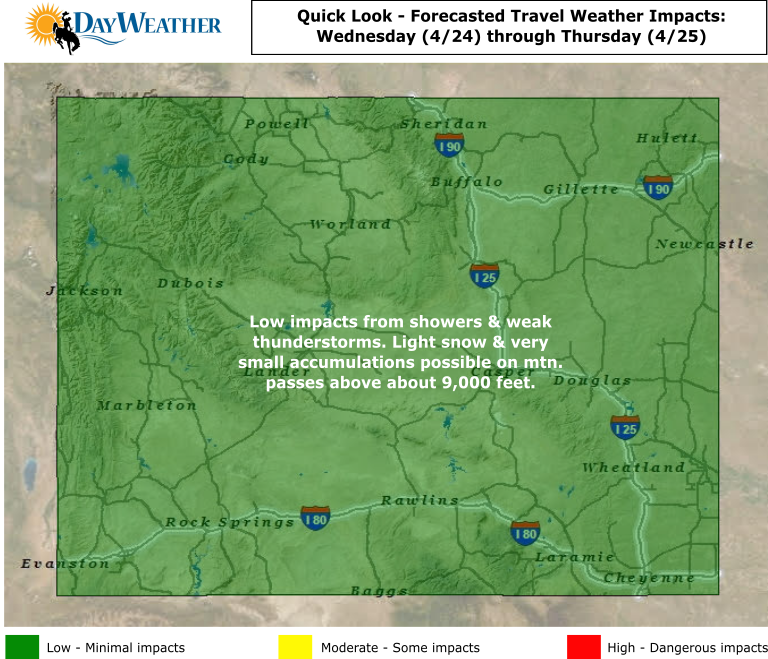
Road Impact Forecast: LOW impacts from rain/snow showers and a few weak thunderstorms across western, southern and central areas.
Shower and thunderstorm activity will be more widespread on Thursday and the activity will also be better rain producers. A few strong to isolated severe thunderstorms cannot be ruled out Thursday afternoon or evening in the east and southeast. The main threat of severe weather though will be to the east, southeast of Wyoming. Snowfall today and Thursday will be limited and confined to elevations above about 9,000 feet. However, the snow level will be dropping on Thursday night into Friday.
A moist and cool Pacific low pressure system will then wind up over eastern Colorado and western Kansas on Friday. This weather system is not cold enough to produce snow below about 7,000 feet. However, moderate to heavy spring snow will be likely across the state's mountains starting on Friday. Friday night and Saturday look to be the best timeframe here now for accumulating mountain snowfall but some will linger into Sunday. Saturday night could also bring the snow level down to about 6,000 to 6,500 feet! Widespread light to moderate rain will be falling across much of Wyoming come Friday and Saturday. Precipitation amounts in excess of an inch will be likely in areas. Some precipitation will linger into Sunday. Please see the extended outlook below.
TODAY:
Rain/snow: Scattered rain showers and a few weak thunderstorms with higher elevation snow showers across western, central and southern areas. The snow level will drop to about 8,500 feet. Please see the graphic below.
Winds: Light to breezy, below criteria winds statewide.
Temperatures: Highs upper 60s to lower 70s for the plains with upper 50s and 60s in the valleys with 40s and 50s in the mountains. Lows teens to 20s in the mountains with 20s to lower 30s in the valleys and 30s in the plains.
Road Impact Forecast: LOW impacts from rain/snow showers and a few weak thunderstorms across western, southern and central areas.

THURSDAY:
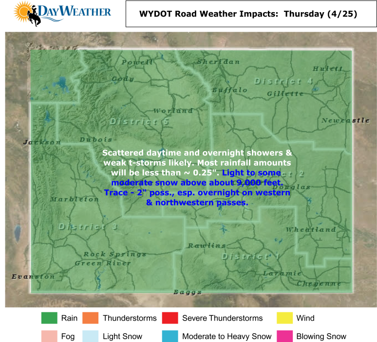
Rain/snow: Scattered rain showers and thunderstorms with a threat of strong storms in the east. An isolated severe storm cannot be ruled out near the Colorado/Nebraska border. Higher elevation snow showers across western, central and southern areas. The snow level will drop to about 8,500 feet by nightfall. Please see the graphic below.
Winds: Light to breezy, below criteria winds statewide.
Temperatures: Highs upper 60s to lower 70s for the plains with upper 50s and 60s in the valleys with 40s in the mountains. Lows 20s in the mountains with 20s to lower 30s in the valleys and 30s in the plains.
Road Impact Forecast: LOW impacts from rain/snow showers and thunderstorms. Chance of MODERATE impacts Thursday night on mountain passes.
EXTENDED OUTLOOK - Friday(4/26) through Sunday(4/28): Highs will drop into the 50s and a few lower 60s for the plains on Friday with 40s and 50s in the valleys and 30s to 40s in the mountains. Light to moderate rain and weak thunderstorms will be commonplace across the state. Moderate to some heavy snow will be found across the mountains. Especially for the western and southern mountains. 6-12" will be possible above about 8,000 feet by Saturday morning. Saturday and Sunday will be chilly and wet, spring days. Highs in the 40s to 50s can be expected in the plains this weekend with 40s in the valleys and 30s in the mountains. Saturday will continue to be wet with snowfall above about 7,000 feet and cold rain below about 7,000 feet.


 RSS Feed